


- Main
- Related Portals
-
Related Webpages
- Reconstruction and interactive maps of Shrewsbury c1630
- Llanymynech Limeworks Heritage Area
- Introduction to the Interactive Map of Much Wenlock c1475
- Introduction to the Ludlow 1768 Interactive map
- Introduction to Interactive map of Llanymynech in 1901
- History of Whitchurch: Timeline and interactive map
- Oswestry Town Trail - Introduction to interactive map
- The suburb of Harlescott, Shrewsbury
- Acton Scott and Shropshire's Farming History Interactive Map
To expand and collapse the navigation please click on the headings
Go to other Related Subject areas
Interactive Maps and Town Trails

.
Explore Shropshire's fascinating past with a range of interactive maps and trails.
Shrewsbury around 1630. An interactive map of a Tudor and Stuart Town.
This is a reconstruction of the Shrewsbury Abbey area c1630. By this time the monastery had been closed for almost 100 years. However the ruins of the chancel could still have been seen and other ex-monastic buildings had new uses. The Abbey church was r...
Follow the links to explore Shrewsbury and its inhabitants during Tudor and Stuart times.
The bird's eye view is linked to a wealth of photographs, paintings and engravings associated with life in this important Tudor and Stuart town.
There are images of Tudor and Jacobean buildings many long since disappeared.
There are biographies of Tudor people, merchants, lawyers, women and schoolboys based on actual documentary evidence or you can spend a day in the life of some of the characters.
You can let your cursor do the walking through the old streets of the town and click on individual buildings to link with a huge number of captioned old images of the town.
There is a downloadable Tudor Town Trail to take you around modern Shrewsbury and show you what is left of the Tudor town.
Related Links on other Websites
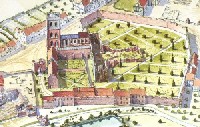
Much Wenlock around 1475. An interactive map of the town towards the end of the Middle Ages.
An interactive map of Much Wenlock around 1475.
The aim of the reconstruction map of the town is to portray it as it was when the town was still prosperous and the priory intact.
Before its dissolution and destruction in the 16th Century the priory would have completely dominated the town, not only by the sheer bulk of its buildings, but by its economic, social and political power too. The priory’s demise was one of several reasons for the stagnation of the town in later centuries.
However this lack of change preserved the old houses of the town until the 20th Century when such antiquity was seen in a positive light. The result is that Much Wenlock is the best preserved medieval town in Shropshire and one of the finest in England.
Related Links on other Websites
- Click here for the Much Wenlock interactive map
Ludlow in 1768. An interactive map of the Georgian town.
Reconstruction of Ludlow in 1768.
Ludlow in 1768 was a town in transition. Much of what can be seen in the map remains today, but aspects of an earlier Ludlow, that of the medieval, Tudor and Jacobean periods, much of which has vanished, can also be glimpsed.
The aim of the project has been to make the research of the Ludlow Historic Research Group more widely available by linking it to an interactive map of the town.
You can now see detailed histories of over 70 buildings in the town, often illustrated by old paintings or photographs. These will be complemented by a range of themes about the town’s history particularly focusing on the mid 18th century when Ludlow was at the height of its Georgian prosperity.
Related Links on other Websites
Whitchurch Timeline and interactive map
Whitchurch is an important market town in the north of Shropshire.
Originally a settlement founded by the Romans around AD 52 or 70, it was called Mediolanum, meaning The place in the middle of the plain. The settlement was located on a major Roman route between Chester and Wroxeter.
Follow the link below to more information about the history of Whitchurch from prehistoric times until the present day.
Related Links on other Websites
Oswestry Town Trail and interactive map
Oswestry is only a few miles from the Welsh border and, until 1535, changed hands several times. Although it has been an English town since then, many of its residents can claim a Welsh background.
Oswestry’s situation and importance as a market town meant that trade between the two countries flourished here.
Related Links on other Websites
Acton Scott in 1900. An estate and farm in the Shropshire hills
Acton Scott Historic Working Farm shows what life was like on a Shropshire hill farm at the start of the 20th century.
At this time, the horse was the main source of power and therefore no tractors are used here. As the name suggests, this is a working museum. We show seasonal farming activities, craft skills and the home life of the people who lived and worked here.
Follow the link below for an interactive map of the home farm and estate.
Related Links on other Websites
- Click here for the Acton Scott interactive map
Llanymynech in 1900. A lost industrial landscape.

The Hoffmann Kiln chimney is the most visible reminder of Llanymynech's 19th and early 20th Century lime industry.
Llanymynech on the Welsh border of Shropshire has a fascinating industrial history.
The once thriving limestone quarries and lime burning kilns at Llanymynech, which serviced the huge demand for lime in the 19th and 20th centuries, fell into disuse in 1914 and finally closed in the 1930s. The area is now recognised as one of national historical significance.
Llanymynech is the site of a huge Hoffman Kiln, which has recently been restored.
The Hoffman Kiln was named after a German, Friedrich Hoffman who patented it in 1858. It was intended for brick making but it was soon realised that it would suit the production of quicklime too.
Related Links on other Websites
Harlescott, Shrewsbury in the 1930s. Development of a suburb
Harlescott is a suburb of Shrewsbury situated on the northern side of the town. The name is derived from an old Scandinavian name and means the cottage of Heorulaf. It started to be developed in the 1920’s.
Prior to this it was mainly an agricultural area with a small village situated along Harlescott Lane. In the 1850’s it had a carpenter, bootmaker and publican.
The area is continuing to develop with new industrial sites at Battlefield, sports facilities and retail areas.
Related Links on other Websites
- Click here for the Harlescott interactive map
