


To expand and collapse the navigation please click on the headings
Go to other Related Subject areas
How the Shrewsbury 1630 map was created

How the 1630 view of Shrewsbury was created
Stage 1 Finding the artist
We wanted an artist with experience in reconstructing past townscapes, and with a good knowledge of architecture. Phil Kenning had worked on reconstructing buildings in Spon Street for Coventry City Council and has long experience of using architectural drawings. He was also prepared to enter uncharted territory in reconstructing an entire large town. He would need to be flexible in being prepared to modify his drawings in the light of new information. In all these respects we were not to be disappointed.
Stage 2 The choice of base map
We needed the earliest map that had reasonably accurate “footprints” of buildings on it. The Ordnance Survey 1st edition would have been highly accurate, but much of the “Tudor” town had disappeared by 1884. This included major changes to the Castle area with the coming of the railways in 1848 and the destruction in the centre of town necessitated by the construction of the Victorian Market Hall in 1860s. The Burghley (1575) and Speed (1610) views were of the right period, and Burghley was later to provide much valuable information, but both lacked sufficient detail. Rocque (1746) was to be extremely useful in other ways, but individual building plots are not marked on it. In the end we plumped for John Wood’s map (1838).This was digitally copied and a CAD (Computer Aided Design) version produced. This enabled the map to be skewed to the desired viewing angle for the town. Buildings that appeared after 1630 were marked, but several important structures existing in 1630 had disappeared by 1838 and would have to be superimposed on the map. Mistakes were initially made in identifying the exact location of certain buildings and no doubt a few of these mistakes, not spotted by us, have persisted through to the finished painting.
Stage 3 The scope of the map
It had always been the intention that as much of Tudor Shrewsbury be portrayed as possible, but we could now see how viable this was. We had to make sure that the streets and buildings could be portrayed large enough to be recognizable, whilst at the same time ensuring a wide coverage. Compromises would be needed. It was agreed with the artist that Abbey Foregate would be produced on separate boards and, by sacrificing much of the Quarry Park (but not so much that the sense of Shrewsbury in a loop of a river was lost), a larger scale image was made possible. The portrayal of the fascinating, but inconveniently long, Abbey Foregate has clearly been a problem for earlier cartographers. Burghley left it off altogether and Speed artificially shortened it. The “kenning” map includes it all as far as the old leper church of St Giles. However, Burghley and Speed succeeded where we didn’t because we took the hard decision to leave out the historic suburb of Coton Hill.
Stage 4 The date of the map
The choice of 1630 was dictated by a number of factors. The “Tudor” Shrewsbury of most people’s imagination strictly speaking is actually “Tudor and Jacobean”. We didn’t want to leave off the Jacobean structures such as Rowley’s Mansion (1618) or much of what was Shrewsbury School (1630). There may even be some buildings on our view which actually post date 1630, as the timber framed building tradition carried on until the third quarter of 17th Century. Dating by dendrochronology (by counting tree rings) of now demolished buildings which may have fallen into that category is of course impossible.
1630 is also a date which should allow the use of the map by primary school pupils studying the Tudors, and secondary students studying the Making of the UK, units of the National Curriculum.
Stage 5 The images
There were four main sources of images.
Firstly; the DSH team photographed every surviving medieval or Tudor, building in the town and suburbs. Many surviving buildings were re-fronted in the Georgian period usually before any record of their previous appearance was made. Inevitably these appear as conjectural buildings on our view.
Secondly; the superb collections of Shrewsbury related oil paintings, watercolours, engravings and old photographs on two local web-sites, “Secret Shropshire” (Shropshire Archives) and “Darwin Country” (Shrewsbury Museums Service) were trawled for images of demolished Tudor and earlier buildings. We had to check these against other images for evidence of “artistic license”. We also had to accept that these paintings rarely dated to before the late 18th Century, and much may have changed between1630 and the time the painting was created.
Thirdly; the old photograph collections held by Shropshire Archives filled in gaps left by the web-sites.
Fourthly; non-local collections such as those held by the British Library were examined, as were book illustrations.
The artist was provided with digitised collections of relevant images sorted by streets. Each of the hundreds of images involved was linked to 2nd edition Ordnance survey maps (or sections of John Wood map) identifying the direction in which the photographer or artist was “pointing” and the buildings being illustrated. Occasionally a building would be placed in the wrong place necessitating changes at a later stage.
Stage 6 Archaeological input

This shows the Abbey Foregate area at the end of the drawing stage. The colours underneath were indicators provided by DSH team of buildings for which old images survive (yellow) and of later buildings on 1838 base map irrelevant for a 1630 view (blue.)
Despite Shrewsbury being very well served by artists and photographers there remained big gaps some of which archaeology has been able to close. Independent Archaeologist Dr Nigel Baker and Community Archaeologist, Hugh Hannaford provided much invaluable advice in these respects and have checked the image for accuracy.
Stage 7 Documentary input
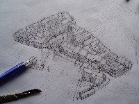
This is an early stage of the drawing process with a number of mistakes to be corrected. St Chad's tower is too high as are properties in Princess Street.
Bill Champion, author of “Everyday Life in Tudor Shrewsbury” has provided much of the documentary content linked to the site. He was also able to confirm the existence of particular buildings unrecorded by archaeologists or artists. In a very few cases archaeologists didn’t agree with each other or the archaeology didn’t easily equate to the documents. The DSH team had to be referees! Despite all our efforts the appearance of less than one third of the town in 1630 is known. The rest of the image is made up of conjectural structures based on known Shrewsbury examples, but their size does relate to the importance of the street they are in – back streets tend to have smaller houses.
Stage 8 Painting
Before the painting stage was reached, the draft drawings of each section of the map were sent to our experts for checking. The greatest difficulty faced was ensuring that the huge wealth of information available was translated into an accurate portrayal on the view and that all that topographical information was included before the painting stage was reached. In reality much had to be laboriously added by our graphic designer after the painting stage. He skilfully created “new” buildings out of parts of other buildings.
Only one image is available of Shrewsbury in the early 17th century, and the colours seen in it were very helpful in informing the artist’s palette. “Black and white” is associated with timber buildings, but this has really only been the case since the early 19th century. Previously oak timbers were usually left untreated and panels were lime-washed white, ochre or even dark pink! In most cases we have had to guess which building would have been painted in which colour. The surviving medieaval stone buildings and brand new brick buildings were more straightforward.
The depiction of the gardens and meadows in and around the town, which were added at this stage, also needed to be as accurate as possible. Here the Rocque map of 1746 proved invaluable. Rocque was a landscape gardener and depicted these features in considerable detail. Comparisons with Burghley 170 years earlier established that, with some exceptions where Rocque depicted more recent developments, there was agreement between the two and so the information could be used with confidence on a 1630 view.
Our view is not populated. The inhabitants of the town seem all to be inside! This was an artistic decision. At the scale the view was painted, people would be like ants. On an internet web page a maximised view, acceptable for buildings, would be disastrous for humans or animals!
Stage 9 The future
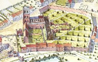
This is part of the finished map, showing the area around Shrewsbury Abbey. It is the result of considerable research and much consultation with local historians and archaeologists.
The 1630 view is intended to perform two roles. It is a piece of research in its own right which brings together a great deal of evidence on the appearance of Shrewsbury in 1630 and makes it available to the wider public in an understandable way in both poster and web-page formats. It is also intended as an entry point for internet users to access a huge variety of resources, both pictorial and documentary, that link to late 16th/early 17th Century Shrewsbury. By clicking on individual buildings and spaces, users will be able to see the images of the town that we used to create the view. They will also be able to read about the inhabitants of some of the buildings and about life in the town at that time. This will be a growing resource with extra information being linked to the view in the coming months.
