


To expand and collapse the navigation please click on the headings
Go to other Related Subject areas
Archaeological Investigations at the Old Welsh Bridge, Frankwell Quay, Shrewsbury

On the 31st October 2006 construction of the Theatre Severn at Frankwell Quay commenced. This new theatre with its 650 seater main auditorium, plus smaller drama and dance studios is scheduled to open during 2008
Construction of this new theatre is being accompanied by programme of archaeological work carried out during 2006-07 by the Museum of London Archaeology Service and sponsored by Shrewsbury & Atcham Borough Council.
It is the aim of this article to summarise this ongoing fieldwork
Topography and Geology
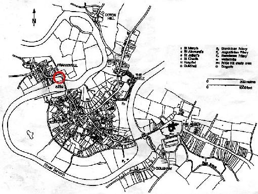
Medieval Shrewsbury showing the site location and the position of English and Welsh bridges and (PP4), source Baker 2002 fig 4
Shrewsbury is a town that is defined by the meanders of the River Severn (fig 1). It is unusual for a major river this close to its headwaters to possess fully developed meanders. The reason for existence of these meanders is the fact the Severn today follows the infilled course of a huge late glacial (Devensian) melt water channel which eroded out a massive channel through the underlying New Red Sandstone. This channel was subsequently infilled with silts and sands. Since the end of the Devensian circa 12,000 BP, it is believed that the Shrewsbury stretch of the upper Severn originated as a glacial meltwater, which stream simply following the line of the larger pre-existing channel. So today the Shrewsbury stretch of the Severn occupies a flat river valley created by much a larger river and infilled with soft sediments, which can easily be eroded hence the development of meanders. Topographically the site of Frankwell Quay formerly consisted of a natural inlet on the inside of the Frankwell meander.
Related Links on other Websites
- Music Hall Redevelopment
DSH cannot be held responsible for the content of external websites.
The Saxon Severn
Geoarchaeological work carried out on site in connection with the Exeter University, Department of Geography has revealed the full sequence of the post-glaical riverine sediments. Over time within this natural inlet there was continued build-up of slow flowing or standing water type sediments. Plant remains show there was vegetational development along the water’s edge (the foreshore). Two organic sandy silt lenses, containing plant remains have radio-carbon dated. The lower one [617] dated to Cal AD 630-710 (Beta 216903, 1360+/- 40 BP), and upper one [611] to Cal AD 540-660 (Beta 216902, 1460+/-40 BP). In historic terms these dates fall within the early /middle Saxon period (circa AD 400-850) and predate the establishment of Shrewsbury by several centuries. It is believed that Shrewsbury was established during the early 10th century as one of a network of burhs or fortified places within the county. Pollen of Saxon date shows a river meadow landscape of grass and wetland trees, but the presence of mixed woodland and cereal cultivation nearby is also indicated.
Frankwell and the building the Welsh Bridge
When the Welsh bridge was constructed is uncertain but it was probably in existence by 1121, when a charter refers to two bridges (presumably the English and Welsh) in the town. It is possible that the early 12th-century Welsh Bridge was constructed of timber not masonry. The previous river crossing was a ford some 150m downstream of the Welsh Bridge.
It is clear from residual 10th-century pottery recovered from medieval overbank flood deposits on the bridge approach that there was some late Saxon activity here. The medieval suburb of Frankwell developed on the opposite bank of the Severn to the town, along the approach road to the northern end of the Welsh Bridge, as result of a result of the traffic and trade the bridge would have attracted. In 1262 there is a record of the receipt of tolls from the Welsh Bridge. Frankwell was first documented in circa 1222 as Frankevilla, meaning free town, free in this context in relation to the surrounding feudal countryside. The implication of the name is that this suburb was relatively new addition and was trying to advertise the fact that it had the same rights and privileges as the town on the opposite bank. After 1160 the Hospital of St George was in existence to the north-east of the bridge, one burial interpreted as part the hospital cemetery was found here during the 2005 evaluation. The bridge was also known as St George’s Bridge because of its proximity to the hospital. The hospital apparently closed during the 15th century.
The Welsh Gate
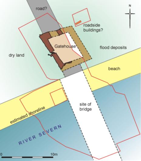
Plan of the trapezoidal masonry building on the approach to the Old Welsh Bridge, probably a gatehouse associated the 12th-century bridge
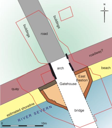
During the 12th century this stretch of the Severn served as the frontier between England and Wales, so both the English and Welsh Bridges were fortified as they served as part of the town’s defences. An undated sandstone rubble trapezoidal building on the approach to the Welsh Bridge is interpreted as a gatehouse probably associated the 12th–century bridge (fig 2).
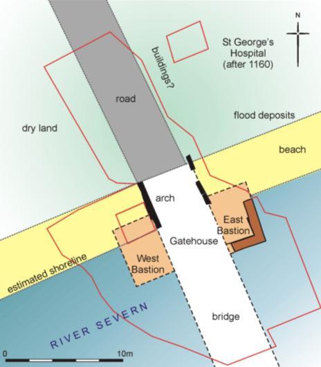
Plan of the square bastions of the 12th or13th-century Welsh Gate. The layout of this phase of the western bastion is conjectural
During the 12th or 13th century it appears that the fortifications of the northern bridge approach were replaced a pair of square sandstone rubble bastions, presumably joined by a gatehouse which spanned the bridge roadway (fig 3). The only dating for this phase of fortifications is sherds of 12th or 13th–century pottery recovered from the levelling dumps post-dating the demolition of the east bastion.
Related Links on other Websites
- Darwin Country Website
DSH cannot be held responsible for the content of external websites.
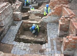
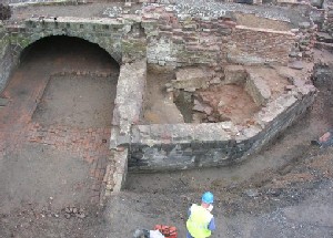
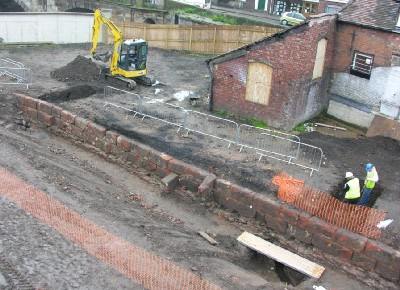
Elements of the east bastion were revealed by excavating small trenches dug through the 19th-century cellar floors, view looking north
The eastern bastion was discovered by excavation of trenches through the floor the 19th–century cellars on the east side of the surviving bridge arch (fig 4). During this period overbank flood deposits were accumulating on the area of higher land to the east of the bridge approach road, where the presence of pits and other features suggest the existence of road side settlement.
During the 13th or 14th century the bastions were rebuilt on a larger scale and faced with sandstone ashlar.
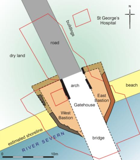
Plan of the enlarged bastions of the 13th or 14th-century Welsh Gate
The new east bastion possessed a diagonal southern end and while the layout of the west bastion is conjectural, but it is likely that it was rebuilt to match the other one (fig 4, 5). This rebuilding may be linked with the 1284 charter which records the bridge had been ‘broken’ and damaged by floods, so tolls were to be collected for three years to pay for its repair. As the collection of tolls was extended for a further five years it implies there a major programme of rebuilding was being carried out. The new west and east bastions were not quite symmetrical. The crucial thing about these bastions is they extended across the line of the present arch, so either this arch did not exist at this period or it was blocked. In circa 1543 the bridge was described as consisting of six arches, when by the 18th century it possessed seven. This gatehouse was shown on the Burghley map of Shrewsbury circa 1575, it is labelled ‘ye Welsh Gate’. This map shows how the Welsh Gate served as barbican to protect the main gatehouse the Margol Gate at the southern end of the bridge from surprise attack. The same arrangement of two gatehouses also existed at the medieval English Bridge at Shrewsbury on London Bridge as part the city’s defences.
Post-medieval modifications to the Welsh Gate
View of the shortened west bastion, view looking east
At some time the western bastion was shortened at which time the bridge arch was either reopened or constructed (fig 6, 7).
Plan of the shortened bastions was at which time it assumed that the bridge arch was either reopened or constructed
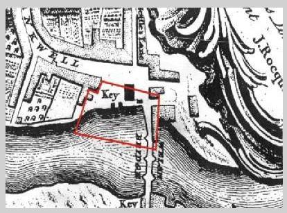
Rocque map of 1746 showing the layout of the buildings and the quayside
Presumably the east bastion was shortened at the same time, but this not known as this portion of the site is unexcavated. This rebuilding perhaps took place in 1608 when Rowland Jenks built a quay at Frankwell as it would have provided vehicular access to the quay from the east. Rocque’s map of 1746 (fig 8), shows that the east bastion had now been replaced a large rectangular building (this is shown on some of the 18th century views of the Welsh Bridge see Darwin Country website) and by this date there was block of houses built on the east side of the bridge too. A watercolour of 1769 shows the bridge open arch (then known as the ‘dry arch’) a quay to the west side of it and how the west bastion had been converted into a cottage.
The New Welsh Bridge
The abutment riverwall, general view looking south
The construction of the New Welsh Bridge (1793-95) downstream caused many changes and a huge sandstone ashlar abutment riverwall or barge quay was built on the up stream side of the new bridge (figs 9, 10).
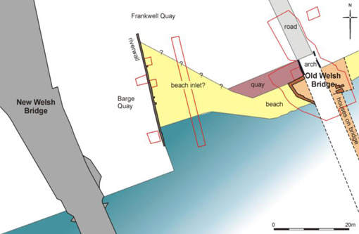
Plan of the Old and New Welsh Bridges, showing the estimated line of the foreshore and the position of the abutment riverwall
An recently discovered map of the Welsh Bridge shows that the bridge and all the buildings occupying its northern end were still intact on the 5th February 1795 (County Record Office). This map also shows a ‘new quay’ wall, aligned east-west, situated some 8 metres south of the bastions (not on any of the figures). This sandstone rubble wall was discovered on site in January 2007 during ground works. It is interpreted as an initial phase of reclamation, which was quickly superseded when it was decided to reclaim the area of the inlet between the two bridges.
The position of the Old Welsh Bridge, superimposed on the OS 1882 (1:500 map) showing the area of reclaimed land
As a result of this reclamation by 1832 this stretch of the river shore line had moved southwards some 30m to its present position (fig 11).
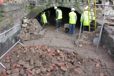
The bridge arch showing the ramshackle blocking inserted in circa 1960, view looking east. In the foreground is the 19th-century brick paved cellar floor
In circa 1796 all of the Old Welsh Bridge was demolished apart its northernmost arch and its flanking buildings, the old bridge became a cobbled cul de sac or alley way. A two-up two-down, brick-built house was constructed above the quay on the west side of the bridge and the area of the former bridge arch incorporated into its brick floored cellar, it was demolished in circa 1960 and the bridge arch blocked (fig 12).
During the early 19th century a brick- built cellared building (probably part of a malt house) was constructed to the over the site of the 18th-century building (overlying the east bastion). There was evidence of enclosed stoves and boilers within these cellars. This building was demolished in circa 1960.
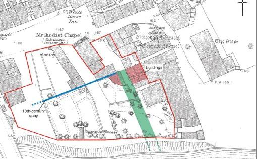
In 1865 a Calvinistic Methodist chapel and school was built at Frankwell Quay on the western side of the former bridge approach. In 1909 the chapel closed and for many years it was the premises of Auto Tyres. This building is being retained during the new development.
Past and future drama on the Old Welsh Bridge

In August 1485, when the Earl of Richmond (later Henry VII) was advancing eastwards with his army to meet Richard’s III forces at the Battle of Bosworth, he decided to cross the Severn at Shrewsbury. The town’s Senior Bailiff Thomas Mytton had ordered that the gates of the Welsh Bridge were to be closed and the bridge be defended as he had vowed that the earl and his men should nor pass over the bridge unless they went over his body. In a piece of drama worthy of Shakespeare Mytton lay down ‘belly upward’ on the bridge roadway so the earl could step over him and allow his honour to be vindicated. Clearly this incident did not harm either Mytton or his career as he was Senior Bailiff again when Henry VII visited the town in 1488. The part of the bridge where this wonderful drama took place is not recorded, but it was likely to have been the northern end of the bridge, perhaps even on the surviving bridge arch, which is to be preserved in-situ under the main stage of the new main auditorium of the Theatre Severn.
By Bruce Watson
Senior Archaeologist
Museum of London Archaeology Service
Bibliography
Baker, N, (ed) 2002 Shrewsbury Abbey, Shropshire Archaeological and Historical Society Monograph Soc Monograph Series No 2.
Harrison, D, 2004 The Bridges of Medieval England: transport and society 400-1800, Oxford.
Newman, J and Pevsner, N, 2006 The Buildings of England: Shropshire, Yale University Press. This excellent revision of the 1956 volume has a detailed section on Frankwell and includes the Old and New Welsh Bridges see page 582.
Trumper, D, 2006 Images of Shrewsbury: from the collections of Shrewsbury Museum Service, Britain in old photographs, Sutton publishing. See page 44 for the bridge arch when it served as a cellar.
Ward, AW, 1935 The Bridges of Shrewsbury. This is the best account of the history of the Welsh Bridge and was reprinted in 1983 by Shropshire Libraries.
Watson, B, Brigham, T, and Dyson, T, 2001 London Bridge: 2000 years of a river crossing, MoLAS monograph 8. See pages 105-09 for more about fortified medieval bridges.
