


- Main
-
Related Webpages
- National Curriculum Key Stage 1
- Interactive Maps and Town Trails
- Oswestry area
- Oswestry Town Trail - Arthur Street
- Oswestry Town Trail - Bailey Street and Bailey Head
- Oswestry Town Trail - Beatrice Street
- Oswestry Town Trail - Church Street
- Oswestry Town Trail - Cross Street and The Cross
- Oswestry Town Trail - Leg Street and Salop Road
- Oswestry Town Trail - Oswald Road
- Oswestry Town Trail - Upper Brook Street
- Oswestry Town Trail - Welsh Walls
- Oswestry Town Trail - Willow Street
- Oswestry Town Trail - Bibliography
- Oswestry Town Trail - Upper Church Street
- Oswestry Historic Town Trail - Whole Map
To expand and collapse the navigation please click on the headings
Go to other Related Subject areas
Oswestry Town Trail - Introduction to interactive map

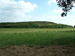
Old Oswestry Iron Age hillfort
Oswestry is only a few miles from the Welsh border and, until 1535, changed hands several times. Although it has been an English town since then, many of its residents can claim a Welsh background. Oswestry’s situation and importance as a market town meant that trade between the two countries flourished here.
In the Civil War Oswestry’s Royalist forces were defeated by the Parliamentarians. The Parish Church was partly destroyed during fighting in 1644 and, soon afterwards, the castle and town walls were destroyed. The four town gates on the main roads into town remained and acted as toll gates until the 1780s when they too were demolished.
The road layout changed very little for several hundred years – a few houses came down and more were built but, apart from Church Street, the roads remained narrow, Beatrice Street, Willow Street and Brook Street all had water flowing down them, often collecting in stagnant pools. By the 1800s, trade was flourishing, especially after the railway came to Oswestry and there was more money to spend on improvement schemes. The more affluent residents wanted to improve their homes and the streets they lived in. Several of the streets were widened or straightened to make travel easier, and were paved, the surface water being routed underground. Old houses were pulled down and smart new town houses took their place. The workers were not forgotten. White collar workers moved into new houses such as those in Ferrers Street, while streets of terraced houses in the area around Gate Street and Rope Walk housed factory and railway workers.
Oswestry had a century of relative prosperity, taking advantage of all the new inventions etc. which made life more comfortable. A hundred years after the railway came to Oswestry, it came to an abrupt end with the coming of the Beeching era of railway ‘improvement and efficiency’. The loss of the railway meant the loss of many jobs in Oswestry but the town survived and is now, once again, a thriving hive of industry with new industrial estates on the outskirts of town providing work for its people.
Unlike many small towns which have lost their individuality, Oswestry remains a town of small individual shops, a thriving market, and very few chain stores.
To access the interactive town map click on the "Oswestry Historic Town Trail -Whole map" button in the side menu.
